
Canton Neighbors Records
Official sources describe different parts of a block. The Canton GIS Division documents parcels, buildings, roads, utilities, catch basins, tax maps, zoning maps, and street-map resources. The interactive AxisGIS viewer needs a live click or identify action, and its complete field inventory was not exposed in the research. The assessor and Registry then add ownership and recorded-instrument details. A municipal voter request can concern public records, but it is not a shortcut to a complete block roster. Treat each record as a dated answer to a specific question.
| Source | What It Shows About a Block | Access |
|---|---|---|
| AxisGIS | Parcel geometry, buildings, roads, and local map context | Public JavaScript viewer; identify-result fields were not text captured |
| Canton Assessor's Database | Owner of record, parcel, property description, sketch, map, and possible mailing field | Current FY2026 portal; verify live fields or request a record |
| Norfolk Registry of Deeds | Party roles, deeds, plans, legal descriptions, and ownership chronology | Recorded research from 1793; Registered Land Court search is separate |
| Canton municipal voter record | Public registration fields that the election office may release | Local request; statewide voter file is restricted |
| Canton Library directories | Dated address and household clues | In-person historical collection with known gaps |
Canton neighbors in this context means people or entities connected to adjacent parcels, not everyone who may live near an address. A physical block can include lots with different street names, corner parcels, or a road edge. Start with the parcel boundary, then decide whether a separate ownership, historic-directory, or civic question is supported by the source.
Define Canton Neighbors by Parcels
For a Canton neighbors search, an adjacent parcel is the practical definition of neighbor. It is a lot that touches the subject parcel or shares an immediate map edge. That definition is more precise than drawing a radius around a house number, and it does not claim to identify all residents on a nearby road. Record the subject parcel's map-lot or other identifier first, then record the matching identifier for each immediate abutter before looking up a name.
Owner and occupant are different facts. The assessor's owner of record may be an individual, trust, estate, or business entity. A person shown in a deed may be a trustee, executor, mortgagee, or another transaction party. If a parcel card has both a situs address and a mailing address, the situs is the physical lot and the mailing field is correspondence information. Neither field alone proves a person's current residence. Note: A map edge establishes a parcel relationship, not a personal relationship between the people associated with the lots.
Mapping Canton Neighbors by Parcel
Use the address-to-abutting-parcel route to keep a Canton block search within the documented geography. The official map and parcel viewer are orientation tools first. Before attaching a name to any lot, capture the source date, map-lot or parcel identifier, visible street or legal description, and whether the viewer is showing the subject parcel or a nearby feature. Search adjacent parcels one at a time. The process avoids turning a broad map view into a claim about occupants.
- Check the official street map and retain the street number, spelling, suffix, and grid location.
- Open the Canton AxisGIS viewer and use its available identify or parcel-map function to locate the subject parcel.
- Record the immediate touching parcels or map edges as possible abutters, along with their parcel or map-lot identifiers.
- Search each abutting parcel separately in the assessor record for the owner of record and any displayed situs or mailing distinction.
- Use the Registry only after a parcel or deed reference connects the party to that particular lot. Test Recorded and Registered Land Court paths where appropriate.
For a longer chain along a named road, use the Canton street directory route. It is better suited to an entire street than an immediate block edge. GIS geometry remains context, even when a label or layer appears persuasive.
Canton Map Grid and Street Cautions
The town's 2022 Street Map and List uses an A through J and 1 through 11 grid. It also marks unaccepted ways, partially accepted ways, private driveways, paper or no-access streets, the Stoughton and Sharon lines, and nearby municipalities. The current GIS page links 2026 street-map and list resources. Write down the grid reference before matching a street name to a parcel, especially where a name is short, a suffix varies, or a nearby-town label appears.
A private, unaccepted, or paper street can appear on the list without working like an ordinary public travel route. A boundary label does not give a Canton parcel a second municipal address. No verified Canton-wide street-renumbering or renaming project was found in the inspected sources. When an old number fails to match, compare map editions, tax maps, legal descriptions, plans, and adjoining parcel geometry instead of assuming the number changed.
Canton Neighbors GIS Layer Limits
Canton GIS layers can clarify how a block is built. Parcel outlines, buildings, roads, utilities, catch basins, and linked tax or zoning maps provide physical context. MassGIS property-tax parcel data can also help visualize the geography when the town viewer is difficult to render. Those layers do not verify a person, an occupant, a mailing recipient, or a current relationship to the property. Verify ownership against the Canton assessor and the Registry, and preserve the fiscal year or recording date.
The Assessor's Office says it maintains ownership records, detailed property descriptions, building sketches, and maps. Its dynamic database advertises search, sort, and filter functions, but the inspected material did not expose a full list of live search fields or result-card labels. Use the exact labels currently displayed or make a focused records request. The FY2026 database describes assessments as of January 1, 2025, so a value should always retain its fiscal context.
Canton Neighbors Through Deed Chains
After a parcel record gives a deed reference, use the Norfolk online research guide to move from the current owner to earlier instruments. Record the grantor, grantee, execution and recording dates, book and page or document number, legal description, plan references, and prior-instrument reference. Then search an earlier grantor as a possible prior grantee. A recorded deed can reflect a sale, mortgage, release, easement, or other event, so do not describe every named party as a neighbor.
Norfolk recorded-land research reaches 1793 online, while online Registered Land Court owner and index material begins in 1973. Address indexing is substantially stronger from 2003 forward. For an older Canton block, plan-book references, bounds, lot numbers, and legal descriptions can be more useful than a present-day address field. A no-result search in one system is a reason to check the other system or ask Registry staff for the correct research route, not proof that no parcel history exists.
Note: A dated tax-taking posting can bridge map-lot, address, assessed owner, and deed reference, but it is not a complete current tax roll.
Canton Neighbors in Dated Directories
Historic Canton directories are corroboration, not a current block list. The Canton Public Library's resident-directory holdings run 1939 to 1947, 1949 to 1950, 1952 to 1953, 1955 to 1961, 1963 to 1964, and 1966 to current. The holdings description says entries carry name, address, occupation, and year of birth. Search a surname and street together, and compare the source year with deeds, valuation records, historical voter lists, phone books, or annual reports. A missing year is an explicit collection gap, not proof that a household was absent.
| Official records | Commercial neighbor tools |
|---|---|
| Name the custodian, record date, parcel or docket identifier, and access limit. | May combine sources, retain stale addresses, and obscure the original record date. |
| Support a narrow ownership, geography, civic-role, or historical question. | Can be a lead only; it does not replace source-by-source verification. |
| Respect withheld and protected fields at the source. | Do not use a compiled result to bypass a protected record or same-name conflict. |
Phone-book holdings are 1956, 1995 to 2002, and 2006 to current, and are not inclusive. They can bridge a gap but may describe subscribers rather than an entire household. For older address questions, directories should be read as a dated snapshot with source and year attached.
Canton Neighbors and Civic Roles
The Canton Master Plan provides a community-organization inventory that can add civic context without pretending to be a member directory. It names Citizens of Ponkapoag, Blue Hill Civic Association, Community Club of Canton, Canton Association of Industries, Downtown Business People's Association, Ponkapoag Civic Association, Canton Garden Club, Rotary, Lions, Blue Hill Lodge, Knights of Columbus, Sons of Italy, Irish Cultural Center, Canton Art Association, and Canton Community Theatre, among others. The research found no official public member rosters for those groups.
| Community source | Appropriate block use | Limit |
|---|---|---|
| Canton Master Plan | Identify named community organizations and civic context | Inventory only, not a household or member list |
| Canton Public Library and Historical Society | Check dated newspapers, annual reports, maps, and local-history material | Historical association is not current residence proof |
| Canton Agenda Center | Find a public board or committee role tied to an agenda or minute date | Not a generalized resident list |
The Canton Agenda Center provides time-period, start-date, end-date, search-term, and category filters for public agendas and minutes.
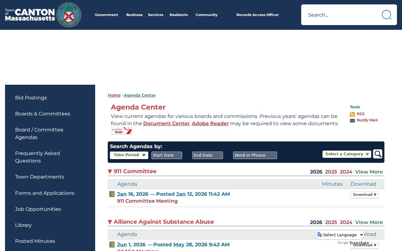
Use an agenda or minute to document a public civic role on its meeting date. It does not establish where a participant lives, who belongs to a group, or who occupies a nearby parcel.
Canton Neighbors Privacy Limits
Massachusetts public-record rules do not make every person near a parcel searchable. The public municipal voter record can contain specified public fields when requested from the local election office, but phone, email, veteran status, permanent-absentee status, minor records, and confidential-voter material may be withheld. The statewide voter list is not a public record. The individual voter-status tool is for an individual's own status and cannot create a block roster. Utility, delivery, and private contact data are not a lawful substitute for public parcel research.
Massachusetts Address Confidentiality Program protection under G.L. c. 9A and 950 CMR 130.00 uses a substitute address and mail forwarding for eligible survivors and protected health-care providers. A confidential voter's name and address are not entered in the ordinary public state database. Sealed, impounded, minor, and other protected records remain protected even when another dated property or map record exists. Use the Canton Records Access Officer for a narrow public-record question and expect lawful redactions.
Lawful use. Use Canton neighbor records for lawful personal, historical, civic, or property research. Do not use parcel or civic information to stalk, harass, intimidate, or harm another person.